
New technology will now give cyclone warning in the Bay of Bengal area before satellite
Indian scientists have discovered a precise technique that will detect tropical cyclones forming over the North Indian Ocean region even before satellite information.
Early detection of tropical cyclones will have a great impact on the socio-economic situation. So far, their detection has been the fastest through remote sensing technology. However, with this remote sensing technique, detection was possible only when the upper surface of the ocean water is warming and a low pressure area is forming. There is a very long interval between its detection and the cyclone coming into existence, which gives time to prepare.
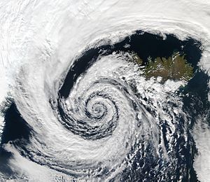
Before the cyclone comes into existence, due to the formation of a warm atmosphere on the sea surface, the atmosphere becomes unstable and the air becomes vortex. This activity triggers upheaval in the atmosphere. The atmosphere created by this type of tornado, in turn, gives rise to strong storms and a low pressure area is formed over the surface of the sea. The possibility of a strong storm is detected by these activities.
Jia Albert, Bishnupriya Sahu and Prasad K. of IIT Kharakpur. A team of scientists like Bhaskaran has devised a new technology under the Climate Change Program (CCP) in collaboration with the Department of Science and Technology. It uses tornado-detection technology and can provide an early warning of tropical cyclone formation over the North Indian Ocean region. The researchers have published their research on this topic in the journal ‘Atmospheric Research’.
The purpose of the technology developed by the scientists is to get clues of tornadoes and whirlwind wind before the storm comes. Scientists base this on the shortest distance between two objects to identify and analyze the swirling wind. Its scale is 27 kilometers and nine kilometers. By evaluating the picture formed from this, it is found out what can be the future condition and direction of the storm. In this study, four severe post-monsoon storms were subjected – Phailin (2013), Vardah (2013), Gaza (2018), Madi (2013) and two post-monsoon storms – Mora (2017) and Ayala (2017). 2009), which were built over the North Hind Ocean.
The team of scientists noted that with this technique, at least four days (about 90 hours before) the arrival of the storm can be detected, when it will form. This includes storms that occur both before and after the monsoon. Tropical cyclones develop over the upper surface of the atmosphere and are caught early in the pre-monsoon period, whereas post-monsoon weather cannot be captured as rapidly. In this study, tornadoes and whirlpools were thoroughly investigated, their behavior was tested and their results were compared with the atmosphere of normal days.
With this technique, traces of tropical cyclones can be traced in the atmosphere itself. This technique is faster than the satellite’s capture of movement above the sea surface.