Uttarakhand: Earthquake panic in Uttarkashi, ISRO revealed – 5.4 cm earth subsided in Joshimath within 12 days
The clouds of trouble are getting deeper in the hill state of Uttarakhand. While the matter of land subsidence in Joshimath still stands as a major crisis, there is news from Uttarkashi that an earthquake of magnitude 2.9 has been felt here. There is no news of any damage so far, but looking at the condition of Joshimath, everyone is afraid that even a slight tremor of the earthquake can cause major devastation. Top officials of the administration are on alert mode.
Earthquake in Uttarkashi
An earthquake of magnitude 2.9 hit Uttarkashi at 2.12 pm. Both Uttarkashi and Joshimath fall in the Garhwal region of Uttarakhand and the distance from Uttarkashi to Joshimath is 285 km.
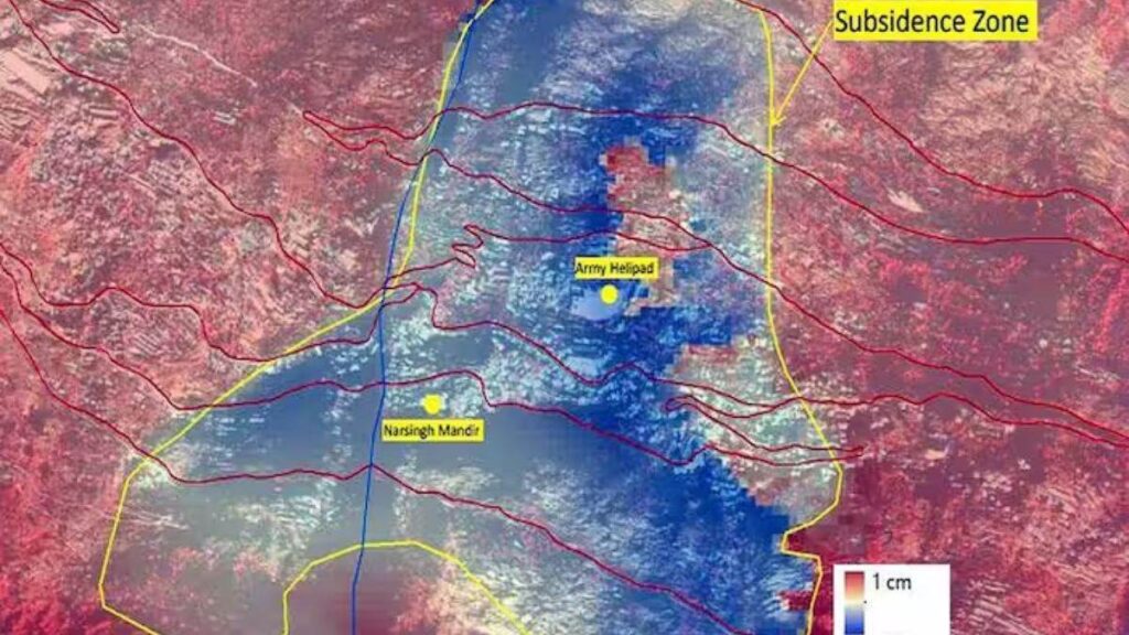
Joshimath’s satellite picture surfaced
The Indian Space Research Center (ISRO) has released satellite images of Joshimath, showing how fast the city of Joshimath is sinking. The National Remote Sensing Center associated with ISRO has released such a picture for the first time. According to this, in the last 12 days, the land of Joshimath has sunk 5.4 cm.
According to the information, the pictures have been taken from the Cartosat-2S satellite. It can be clearly seen in the pictures that which area of Joshimath is sinking and which house or building has reached a dangerous condition. The red stripes seen in the satellite images are roads. The blue colored background is the drainage system under Joshimath city.