
ISRO’s satellite images revealed! Kheer Ganga has returned to its old place – Uttarkashi Cloudburst
b
Relief and rescue work is going on continuously in Dharali of Uttarkashi. On one hand, army personnel are trying to safely evacuate people trapped in the debris. On the other hand, scientists are trying to understand the real reason behind this disaster.
Meanwhile, ISRO i.e. Indian Space Research Organization (ISRO) has released some satellite images of Kheer Ganga. The results that scientists have drawn after seeing these pictures are shocking. Let us understand in this article what these satellite images released by ISRO say.
ISRO released satellite images of Uttarkashi disaster
ISRO has generated some images of Kheer Ganga through its Cartosat-3 satellite. Cartosat can take very clear and detailed pictures of the earth’s surface. In these pictures, you can clearly see this area of Dharali where debris is spread. Senior Geologist Prof. M.P.S. Bisht explains that the catchment area of Kheer Ganga is 50 to 100 metres wide in the lower part and it is connected to the glacier of Shrikanth mountain with a steep slope.

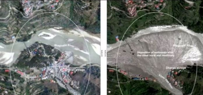
ISRO released pictures before and after the flood from Cartosat-2S satellite
From which it is clear that the settlements in the lower areas have also been built on a pile of debris. Earlier too, heavy debris had accumulated here. Humans built their settlements on top of that debris. Now in this year’s flood, debris has once again spread in the catchment area of Kheer Ganga.
ISRO has released pictures before and after the flood from Cartosat-2S satellite. In the satellite image of the devastation in Uttarakhand released by ISRO, it can be seen that the debris is spread over an area of 20 hectares. Which is up to the banks of the Bhagirathi river. The path of the river has completely changed. Many buildings have submerged or completely disappeared. Dharali village has been completely ruined.

Kheer Ganga has taken back its old place
If scientists are to be believed, the river (Kheer) has taken back its old area in this way. Often rivers do this, they come in their original form and take back their area. That is why NGT has also made rules that there should not be any settlement on the left or right side of 100 meters of any river. But in these pictures it is visible that how the path of the river was diverted by building buildings in the river area.
Scientists had warned earlier also
It is not that scientists, experts and environmentalists had not warned about this earlier. Many people had already predicted this disaster. Scientists had said years ago that Dharali is situated on a time bomb.
Now a similar story is also of the famous Harshil valley near Dharali. However, there was not much population there, due to which no one was harmed there.
It is not nature’s fault, it is our fault?
Prof. Bisht clearly says that the Dharali disaster is a lesson for us. Dharali has once again shown us the mirror that it is not nature’s fault but our fault. Perhaps unplanned development is taking our Uttarakhand towards planned destruction.