Another cyclone ‘Jawad’ to form over Bay of Bengal next week

Another tropical storm may strike again in the Bay of Bengal sometime next week. Earlier, Cyclone Gulab had appeared over North Bay of Bengal on 26 September 2021, and came near Srikakulam in Andhra Pradesh. The storm spread over the central parts and later recurred in the Arabian Sea as Cyclone Shaheen. The cyclonic storm is very likely to form over central Bay of Bengal around October 13 and remain significant over Andhra Pradesh in the next 48 hours.
According to Skymet Weather, a Cyclonic Circulation is expected to form over the Gulf of Martaban and adjoining North Andaman Sea in the next 48 hours. Under its influence, a low pressure area is likely to form over the same area on October 11. This system will become more effective in the next 24 hours. During this period, the remnants of another tropical storm from the South China Sea will move into Vietnam, Laos and Thailand and eventually disappear along with the seasonal system over the North Andaman Sea.
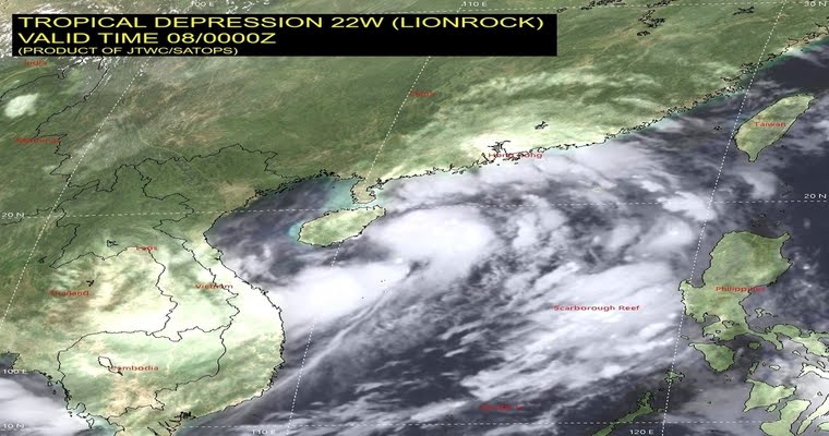
A tropical cyclone ‘Lionrock’ has already formed over the South China Sea and is moving towards the Chinese province of Hainan, close to the most populous city of Haikou. Thereafter, the weakening storm will enter the Gulf of Tonkin, gain strength and make an impact in parts of Vietnam. The storm will weaken into a depression over rough and mountainous areas and the rest of the weather system will pass through Laos and Thailand to reach Myanmar. The merger with the pre-existing weather system would activate the low pressure area and help in cyclogenesis over the central Bay of Bengal. The first cyclone of the post-monsoon season 2021 over the Bay of Bengal will set the pace for an active stormy season over the Indian seas due to favorable environmental conditions of warm sea surface temperatures and light winds.
In the month of October in the Bay of Bengal, the churning of a severe storm has already taken place. In 2013, Cyclone Phailin, equivalent to a Category V storm (the most severe category to scale), made activity over Gopalpur (Odisha) on the evening of 12 October. It was the first storm to do so in the North Indian Ocean since Cyclone Sidra in 2007. The following year also, an Extremely Severe Cyclonic Storm (ESCS) Hudhud affected the east coast. Cyclone Hudhud made landfall in Visakhapatnam on 12 October 2014 with strong winds of 175 kmph.
The name of the next storm developing over the Indian sea will be ‘Jawad’. This name has come from Saudi Arabia and after this if any next storm is formed then it will be given the name Asani by Sri Lanka. A warning notice has been issued to meet the exigencies of the cyclone.


